Icing of Elevated Structures

Weather systems which produce icing events in North America exhibit large geographic variability, as the conditions which lead to icing require the production of supercooled droplets for transport onto an exposed surface, which in turn requires a specific temperature structure of the atmosphere and the availability of sufficient moisture in the air.

This variability is shown in the maps of icing such as in the ASCE 7 Code, or the NBCC and S37 Code Tables. Neither of the codes provides mapping of potential for rime icing, although they acknowledge that it may be more important than glaze icing in mountainous terrain, suggesting that local studies should be used to quantify the icing accumulations.

In the case of tall and elevated structures such as towers additional large variations are caused by topographic effects due to the speed increase on hills and mountains as well as the lower temperatures with height which provide the opportunity for super-cooling of the available droplets at higher elevations.

The ASCE 7 code explicitly requires that the wind profile with height, including speed-up by topography be applied to the mapped icing given on the maps (with an exponent of 0.35). However, there is no accounting taken of the temperature effect with elevation in creating the necessary freezing conditions, except for a statement on the maps indicating that it is unlikely for freezing rain to occur above elevations of 5000 ft (1500 m).

The ICE Site Specific assessment provides glaze ice accumulation values based on site conditions and wind profile. In addition, for elevations greater than 300 m, it is assumed that the airport observations of solid precipitation indicate that the elevated site is in the supercooled droplet phase, adding to the accumulation of glaze icing. The temperature at the site following an icing period is then used to determine the persistence of accumulated ice in order to determine the maximum wind for the event as well as allow for the further cumulative accumulation if a new event is encountered before all the ice has melted.

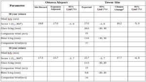
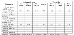
As an example of the typical differences in icing on elevated ground, an Ontario Canada airport data was used to determine the glaze icing accumulation at the base of a tower located on level ground, the same tower on the crest of a 290 m hill, and the same tower on the crest of a 310 m hill. The table below shows the 50 year return icing for the three situations.

Hill Height (m)

50 yr Wind Speed (m/s)

50 yr return Icing (mm)

Companion Wind (m/s)

0

18.8

35

15

290

32

42

22

310

33

48

23

In this case the speed up by the hill produces a factor of 1.7 increase in speed at 10 m above tower base. The 50 yr return icing amount increases from 35 mm to 42 mm or a factor of 1.2 increase. In this case the increase in icing accumulation is equal to the 0.35 power of the speed increase. However, this accumulation increase is sensitive to the amount of precipitation vs wind speed parameter in the icing equation, so it will vary for different situations.

This case also shows an increase from 42 mm to 48 mm (14% increase) for a situation where the hill height is greater than 300 m and it is assumed that frozen precipitation was likely to have been in a supercooled liquid state at the 10 m level of the tower and higher.

The ICE Site Specific assessment also estimates the accumulation of rime ice on an elevated tower or for a tall tower for different heights on the tower. This uses the ISO 12494 recommended procedure and airport observations of cloud ceiling and temperature to determine when the tower is protruding into the cloud layer. The temperature at the height is used to determine whether supercooled droplets are available as well as to determine if melting of the accumulated ice is occurring in order to determine cumulative superposition of the accumulations over time. It is found that at high elevations and for very tall towers on level ground, the rime ice accumulations can have a bigger impact on the tower than does the glaze icing.

Taking into Account the Effects of Climate Change on Wind Pressure at a Tower Site

The new Annex T to the CSA S37-18 Tower Code sets out the requirement on the engineer to take into account climate change in deriving wind loads and icing potential, and contains a discussion of results from the Canadian Climate Models developed by Environment Canada including some relevant results to date. Some of the findings from these models show a high variability across Canada in the values for wind speed extremes, and in particular the statistics of extremes (Dae Il Jeong et al, Atmosphere 2019, 10, 497). This leads to significant variability in the impact for different regions in Canada and at the sub-regional scale.

Model results for current scenarios have been summarized on the EC Climate website and in journals, but again do not assist the engineer in obtaining a specific value which he can use in the analysis and design of a tower for a given site. The models produce large volumes of gridded output from model runs for several scenarios of emission, but do not provide the means for the engineer to determine the likely impact for a specific tower site.

ICE Inc has obtained model results from the Climate runs at high resolution and developed analysis tools to extract data for a specific location to produce a 30 year monthly maximum series of wind speed at the 10 m level to permit analyzing the return level wind for the site. By doing this for a current scenario and a future scenario it is then possible to provide a measure of the relative change to be expected for the site due to climate changes. Applying the relative change to the site specific wind results based on historical data then produces a 50 year return level wind which reproduces the trend that the models are showing for the future scenario.

At present the future scenario being used is RCP8.5, which has business as usual emissions, in other words the current increase in GHG will continue into the 2050 time frame, and produce the maximum changes due to climate. As the likely scenario is modified in time and takes into account actual changes in emissions and better projection of the emissions, and as EC runs the models for alternative likely scenarios, the analysis can be recreated for the site to reflect the expected changes at that point. It would be particularly useful if EC created multiple runs with this and other models, as this would produce a higher confidence in the predictions.

This approach allows us to provide the same site specific report format as currently provided with the added results of applying the climate change variation to the historical data. As an example, Table 1 shows the data for Ottawa Airport and a nearby tower site located in an agricultural area, with no topographic influences. The results of 50 and 10 year return level evaluation of the climate data for a 30 year period starting in 2006 are compared to RCP8.5 evaluation in the 2070 time frame, and show a 2.9 m/s increase in the 10 m level wind for 50 year return and a 2 m/s increase for the 10 year return wind. These represent approximately a 12% increase in the wind speed over the current climate.

The last two columns in the table for this site show the effect of applying this relative increase to the historically measured winds at Ottawa and the predicted return level winds using the same statistical approach. When compared on a wind pressure basis this represents a 28% increase in pressure for the 10 m level on the tower. Note that in this approach all of the other impacts of terrain, topography, tower height, etc. are automatically included in the modified value, so the engineer can use the modified value and the modified 95% confidence interval in his design in the same way that he currently uses the expected wind.

For other sites the relative change will clearly be different and may amount to a decrease in the 10 m wind, which is why the analysis from model data is done for each site. See Table 2 for a site near Sudbury as an example of the case where a decrease in extreme wind is expected.

Table 1 Site near Ottawa

1 Based on Environment Canada CanESM2 model for RCP85 scenario (worst case – continue current CO2 increases)

Table 2 Site near Sudbury


What is a Site Specific Wind Assessment

The design of tall structures such as communication towers requires knowledge of the design pressure, both at the surface level (10 m) and as a profile with height above ground. The Building Codes which the engineer follows provide maps or tabulations of derived wind or pressure at the surface level (Basic Wind) with prescriptions for accounting for terrain characteristics, topographic effects, and vertical wind profiles.

Due to the large areas covered by the maps in the US or Canada encompassing many types of local meteorological effects which are not included in the maps, the codes recognize that such information and procedures are not adequate for producing credible wind pressure estimates for special wind zones and local meteorological situations. The codes then recognize the need for a Site Specific assessment of such situations, which are presumed to include recourse to local meteorological data and application of recognized procedures for deriving the wind profile for the tower.

If the engineer then decides to obtain a site-specific wind for a tower site, he finds that the product denoted as “Site-Specific Wind and Ice Assessment” is interpreted differently by organizations which supply site specific studies, although the Building and Tower codes such as ASCE7 (in Section 26.5.3) and TIA 222 (Section 2.64 and explicitly in topographic category 5) require the use of meteorological data obtained at a nearby site and analysis using accepted statistical methods in the literature in order to treat them as site specific assessments. For example if the basic wind from the ASCE maps is used and the user calculates and applies the 4 profile factors specified in the pressure formula per the code prescription, then the user would not call it a site specific assessment.

ICE Inc. obtains hourly wind and other meteorological data from a nearby airport with 30 or more years of record, as well as supporting meteorological data such as precipitation, temperature, humidity, and observations such as gust, freezing precipitation, cloud ceiling, and weather type codes. ICE then performs the statistical analysis to determine the extreme wind speed for any return period required by the user, applies the topographic and terrain corrections using the Simple Guidelines, and models the icing for each event in order to provide vertical profiles of wind for the extreme event, freezing rain and in-cloud icing dependent on tower height, location, and the elevation of the tower site.

Environment Canada uses as its starting point the mapped wind from the NBCC (National Building Code of Canada) in tabular form and applies an equation derived from the Simple Guidelines for topographic influences on the wind profile. Icing accumulation due to freezing rain is per NBCC table, and no rime icing estimate is produced. EC provides a service on this basis which it calls Site Specific.

The Checkwind software from Revolutio (Australia) interpolates the ASCE7 Map or other code wind map to a specific location and performs for the user the topographic and terrain corrections provided in the code. It also calls this a site specific wind.

The ATC (Applied Technology Council) Hazards by Location web site provides wind values by interpolating the ASCE7 wind maps for a specific geographic location, and the user is expected to apply the terrain and topographic correction factors to obtain a wind in accord with the code. They call this a Site Specific wind as well, although there is no charge for obtaining the interpolated wind from the web site presumably in recognition of the fact that the user can do the map interpolation on his own.

Ultimately it is up to the design engineer to decide which product serves his client’s needs. It is easy to see why the engineer would be uneasy about having to make the decision, given that he does not have the full picture of what these procedures entail. This is then compounded by the fact that the same name “Site Specific Wind” is being used for totally different products. As ICE is familiar with the EC data and procedures through numerous comparisons and discussions, the following sets out some of the differences between the ICE service and the EC service and the implications of the two approaches in practice. A more detailed discussion of the differences is provided in a paper available on our web site at ice-inc.co.

As a basic requirement, when different data and methods are compared it is important to establish the basis for comparison. This is particularly critical in the case of the return value for wind speed, because this is not a quantity that is measurable except by indirect statistical inference. In the design process the specifics of the derivation of the wind speed and profile of wind speed with height are essential, so that a comparison of the single value at 10 m is not sufficient to compare available alternatives.

There are several differences between the ICE and EC site specific approach which often produce large differences in the results provided to the engineer.

Read More in the following papers:

https://www.ice-inc.co/wp-content/uploads/2020/02/site_specific-assessment.pdf

https://www.ice-inc.co/wp-content/uploads/2020/02/ICE-Site-Specific-vs-EC.pdf

ICE Inc will be exhibiting at the CONNECT (X) 2020 Conference in Miami on May 18-21

This year ICE Inc will be exhibiting at the CONNECT (X) conference in Miami on May 18-21, 2020.

Please visit us at Booth 132 to discuss our approach to site specific extreme wind and icing assessment and experiences gained in performing nearly 2000 studies in every state from Florida to Alaska.

Our experts will be available to answer any questions you may have about the benefits of site specific assessment and the methodology used to generate our comprehensive reports.


Join ICE Inc at the STAC 2020 Conference & Exhibition on March 31-April 1 at the Sheraton Vancouver Wall Centre

ICE Inc will be exhibiting again this year at STAC 2020 in Vancouver BC.

Please drop by our exhibit booth to chat about our new offering to deal with the requirements for the S37-18 Annex T on impacts of Climate Change or any questions you may have about our Site Specific Assessments for Wind and Icing on Towers.

We are publishing resumes on these topics on this blog to allow you to examine these issues ahead of the Conference. Of course if you have more immediate questions please get in touch with Boris or Simon Weisman at any time.

We look forward to see you at the meeting.

Join ICE Inc at STAC 2019 in Montreal April 24-25

ICE Inc will be exhibiting again this year at STAC 2019 in Montreal. Please drop by our exhibit to see what we are up to and to talk with our principals Simon Weisman and Boris Weisman about any questions you may have.

Boris will be presenting a paper at STAC 2019 on the advances in the methodology for wind and ice extreme analysis.

In particular the presentation will address some of the shortcomings of the codes for determination of wind extremes when compared to experimental studies and how to avoid these shortcomings.

The presentations will also present a primer on determination of glaze icing and in-cloud icing with emphasis on the influence of local topography on the extreme ice loading.

The presentation will also touch on the new requirement in S37 to address the impact of climate change on return period estimation.